Great Allegheny Passage Overview
150 Miles of Continuous Trail
Easy Riding on Gradual Terrain
150 Miles of Continuous Trail
The Great Allegheny Passage winds 150 miles through the mountains of Southwest Pennsylvania and connects Cumberland Maryland to Pittsburgh. Beautiful medallions mark the end points in both Cumberland and Pittsburgh. The Mile 0 medallion is easy to find because it's positioned in the center of the trail in Canal Place. It's a little trickier to locate the one on the Pittsburgh end. It's located on the waters edge at Point State Park where the Allegheny and Monongahela Rivers meet to form the Ohio.
One thing that makes this trail such a destination is that there are trail towns located every ten miles or so that provide the essential amenities. Of course, some towns have a larger selection of amenities than others so do your homework if you plan to overnight at B&B's. Check out the trail towns page for details about the towns and their amenities. There is a very helpful interactive map on the GAP Trail website which shows the amenities available in each town. Click here to view the map.
Consistent Trail Surface
Easy Riding on Gradual Terrain
150 Miles of Continuous Trail
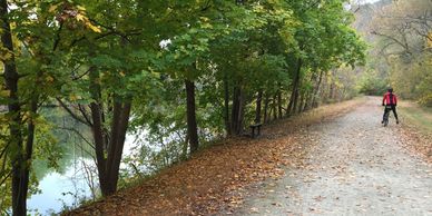
The crushed limestone surface of the Great Allegheny Passage holds up well under traffic and generally provides a smooth ride. While the limestone surface makes for an excellent riding surface, it becomes a bit softer when it's wet. Thinner road tires (23-25mm) typically work just fine until it rains. The high pressure skinny tires are fast when conditions are dry but they tend to sink into the surface when it's wet creating unwanted rolling resistance. There's about 15 miles of paved trail on the Pittsburgh end which extend just south of Mckeesport, and a couple miles of asphalt as you approach Cumberland. Some sections of the C&O Canal are being improved with the same crushed limestone surface used on the GAP.
There is a small army of volunteers who monitor the trail and provide maintenance as needed. It is common during summer months to have strong thunderstorms pass through Western Pennsylvania. Landslides, erosion and trees falling across the trail are no match for this group of trail maintenance super stars. If you encounter a fallen tree or a maintenance related issue on the trail, please report it via email to (admin@gaptrail.org).
Easy Riding on Gradual Terrain
Easy Riding on Gradual Terrain
Easy Riding on Gradual Terrain
Most of the Great Allegheny Passage trail is converted from abandoned rail beds, which makes for a nearly level riding surface with the average grade of less than 1%. The steepest eastbound grade - 0.8% - is from Harnedsville to Markleton and Garrett to Deal. The steepest westbound grade is from Cumberland to Deal at 1.75%. The high point of the trail is where it crosses the Eastern Continental Divide near Deal (2,375' above sea level). From the Eastern Continental Divide heading towards C and O Canal, the trail drops 1,754 feet in 24 miles to reach Cumberland and, going west, it drops 1,664 feet in 126 miles to reach Pittsburgh.
The elevation numbers make this trail sound intimidating - don't worry. Most of the trail is converted railroad bed so the changes are very gradual and often are hardly noticeable. When you look at the elevation charts and From Cumberland to Washington, DC, you drop 625 feet to sea level on the C&O Canal towpath.
Trail Towns & Statistics
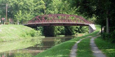
Connecting to the C&O Canal
Easy Riding on Gradual Terrain
The Trail Towns enhance the riding experience on the Great Allegheny Passage by offering the opportunity for regular stops to refuel or relax. Each town is unique and offers its own set of amenities. Part of the fun of planning a multi day ride is to identify your strategy and then target the towns that support your strategy. Which towns have the services you need to support your ride?
Great Allegheny Passage Statistics
- Great Allegheny Passage length: 150 miles (C&O length: 184.5 miles)
- Great Allegheny Passage elevation change: 1787 vertical feet. The elevation grade is a very mild: 1-4% (don't worry, it never feels steep)
- The trail surface is mostly crushed limestone with roughly 20 miles of asphalt (most of the paved sections are in Pittsburgh and Cumberland)
- 3 tunnels
- 2 viaducts
- 1 bone cave
Connecting to the C&O Canal
Connecting to the C&O Canal
Connecting to the C&O Canal
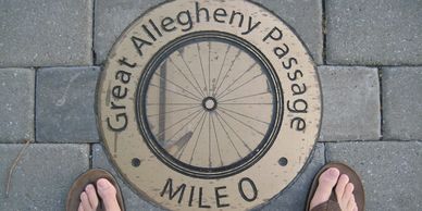
The Great Allegheny Passage connects to the C&O Canal Towpath in Cumberland at Canal Place. The connection is marked with a bronze Mile marker 0 medallion positioned on the middle of trail in Canal Place. You can't miss the trail connection because it's along the Potomac River in the heart of Cumberland.
Head south from the Mile 0 medallion and you are on the C&O Canal Towpath. Check out the historic canal boat just a couple hundred feet south of Canal Place, to get an idea of how the goods were transported on the canal. The canal became a national park to preserve the rich transportation history in addition to the important role that the area played in the civil war.
The Park Service preserves the towpath in a more natural style than the GAP. The trail construction is noticeably different from the GAP because the surface is more like a dirt road rather than an improved crushed limestone surface of the GAP. Improvements are underway which are adding a crushed limestone surface which reduces puddles and creates a more user friendly trail.
What to expect on the C&O
Connecting to the C&O Canal
Connecting to the C&O Canal
The towpath originates on the banks of the Potomac River in Georgetown and follows the river for 184.5 miles. The riding surface of the towpath varies from section to section but is generally more "natural" than the GAP. There are some short paved sections, and a dozen or so miles of manicured crushed stone, but 90% of the towpath looks like the image above. The surface is not terribly rough, but be prepared to navigate around potholes, roots, rocks, and mud. The trail conditions are considerably rougher than those found on the The Great Allegheny Passage which is constructed entirely with a crushed limestone surface. Also, conditions change from month to month due to weather and maintenance. In general, expect conditions to be a bit rougher than your typical crushed limestone surface found on rail-trails. It's best to select a bike and tires that perform well in muddy conditions and feel lucky if the weather stays dry.
The amenities on the C&O are more sporadic than on the GAP. The trail towns are spaced further apart on the C&O but there are many free (first come first serve) campsites positioned every six miles along much of the trail.
cool stuff on the GAP
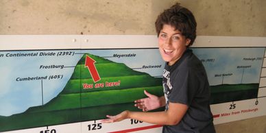
Eastern Continental Divide
Ride through the Big Savage Tunnel on the Great Allegheny Passage
Ride through the Big Savage Tunnel on the Great Allegheny Passage

Whichever direction you're traveling, the Eastern Continental Divide is a significant milestone on the trail because it marks the highest point on the Great Allegheny Passage. Whether you are headed to Pittsburgh or DC, it's all downhill from here. Heading west, the Great Allegheny Passage drops 1,664 feet over 126 miles to reach Pittsburgh.
A road passes over the trail at the Divide so there's a short tunnel. Inside the tunnel there's a map on the wall showing the trail mileage and elevation changes between Cumberland and Pittsburgh. The map makes the 1800' elevation change between The Continental Divide and Cumberland look like an intimidating climb but it's not. The elevation change is spread over nearly 30 miles with the steepest grade being around 1.75%. You can easily ride this trail in both directions.
The Eastern Continental Divide, in conjunction with other continental divides of North America, demarcates two watersheds of the Atlantic Ocean: the Gulf of Mexico watershed and the Atlantic Seaboard watershed. Prior to 1760, the divide represented the boundary between British and French colonial possessions in North America. The ECD runs south-southwest from the Eastern Triple Divide in Pennsylvania to the watershed of the Kissimmee River, which drains via the Lake Okeechobee and the Okeechobee Waterway to both the Gulf of Mexico and the Atlantic Ocea
Ride through the Big Savage Tunnel on the Great Allegheny Passage
Ride through the Big Savage Tunnel on the Great Allegheny Passage
Ride through the Big Savage Tunnel on the Great Allegheny Passage
One of my favorite landmarks on the GAP is the Big Savage Tunnel. On a sizzling hot day in 2010, I climbed the 20+ miles from Cumberland to the Big Savage Tunnel. It was a little before noon and the air temperature was already 94 degrees with no clouds in the sky. The sun was baking me on the climb. The Big Savage Tunnel is at the top of the climb and was a welcome treat because it's like a giant natural refrigerator. The air temperature inside the tunnel was easily 20 degrees cooler than outside. It was so much cooler that a thick fog had formed reducing my vision significantly. The fog was so dense that the ceiling lights weren't able to light the trail...I couldn't see the ground I was riding on. Halfway through the tunnel I could hear the voices of other bikers but they were hidden in the thick fog. They were slowly riding towards me and only became visible once they were within 20 feet from me. It was the coolest thing.
One of the most spectacular views along the GAP is on the southern end of the tunnel. From the top of Big Savage Mountain you can see for miles.
Here's some more details about the tunnel: The Big Savage Tunnel is an abandoned railway tunnel located about 9 miles (14 km) southeast of Meyersdale, Pennsylvania. The Big Savage, Borden Tunnel, and Brush Tunnels are part of the Great Allegheny Passage rail trail. It was originally built for the Connellsville subdivision of the Western Maryland Railway. The mountain and tunnel are named for John Savage, an early surveyor who narrowly avoided becoming a victim of cannibalism in the area in 1736.
Cumberland Bone Cave
Ride through the Big Savage Tunnel on the Great Allegheny Passage
Cumberland Bone Cave
The bone cave is not the most fascinating sight on the Great Allegheny Passage because there's not much to see but it's very unique and worth a stop. The cave is located a couple miles down the hill from Frostburg, and what you can see is a sign sharing the history and the entrance to the cave which has been closed off with a chain link fence. The cave's history is really interesting and it's right on the edge of the trail. In 1912 workers excavating a cut for the Western Maryland Railway along Andy's Ridge broke into the partly filled cave. A local naturalist, Raymond Armbruster, observed fossil bones among the rocks that had been blasted loose and were being removed from the cut. Armbruster notified paleontologists at the Smithsonian Institution, and James W. Gidley began excavating that same year. The cave later became known as the "Cumberland Bone Cave".
Between 1912 to 1916, Gidley excavated the Cumberland Bone Cave, where 41 genera of mammals were found, about 16 per cent of which are extinct. Numerous excellent skulls and enough bones to reconstruct skeletons for a number of the species were present. Skeletons of the Pleistocene Cave Bear and an extinct Saber-toothed cat from the Bone Cave are on permanent exhibit in the Ice Age Mammal exhibit at the National Museum of Natural History, Smithsonian Institution in Washington, DC. Many of the fossilized bones date from 200,000 years ago. The Cumberland Bone cave represents one of the finest Pleistocene-era faunas known from eastern North America.
Today very little of this cave is still in existence, though some excavations are still being performed by the Maryland DNR.
Salisbury Viaduct
Ruins art project, Perryopolis
Cumberland Bone Cave
The Salisbury Viaduct, located along the Great Allegheny Passage in western Pennsylvania, has a rich history and offers a unique cycling experience. Constructed in the late 19th century, the viaduct was a crucial part of the Western Maryland Railway, providing a vital transportation link for coal and passengers.
Today, as part of the Great Allegheny Passage, the Salisbury Viaduct is a popular route for cyclists seeking a scenic and challenging ride. Spanning over 1,900 feet and rising to a height of 101 feet, the viaduct offers breathtaking panoramic views of the surrounding landscape, including the Casselman River Valley and the nearby Laurel Highlands.
Cycling over the Salisbury Viaduct is an unforgettable experience for cyclists of all skill levels. The well-maintained trail provides a smooth surface for riding, and the elevated position of the viaduct offers a thrilling perspective as cyclists pedal across its historic arches. The viaduct is often a highlight of the Great Allegheny Passage journey, offering a glimpse into the region's industrial past and providing a memorable adventure for cyclists exploring this picturesque trail.
Borden Tunnel
Ruins art project, Perryopolis
Ruins art project, Perryopolis
Borden Tunnel is 2.5 miles west (uphill) of Frostburg. The tunnel was bored for two tracks and has a length of 957.5 ft. After the 1975 abandonment, the track was left in all the way up west of the tunnel. It was left to serve a small coal strip mine here. I had a really freaky experience in this tunnel at the end of a long rainy ride from Connellsville.
It was early evening and the rain finally stopped but the air was wet and the sky overcast. Clouds had formed inside the cooler temperatures of the Borden Tunnel. There are no lights in the tunnel so the only light source was coming from the opposite end of the tunnel which was clouded with a cool fog. The light was being diffused through the fog in such a way that I felt like I was riding through a kaleidoscope. It was a really freaky moment. It was as if I were floating because I couldn't see the ground or the walls of the tunnel, just the diffused light coming from the far end. Pedaling through the tunnel towards the light felt like a sneak peak of Heaven. I stopped to take a photo but there was so much moisture in the air (my camera was still wet from filming through the Big Savage Tunnel) that my camera refused to cooperate.
Ruins art project, Perryopolis
Ruins art project, Perryopolis
Ruins art project, Perryopolis
Rachel Sager, a renowned artist, stumbled upon a blank canvas along the Great Allegheny Passage, a picturesque cycling trail. Inspired by the natural beauty of the trail and the region's rich history, Rachel unleashed her creativity through stunning murals that adorned the walls of abandoned buildings, transforming them into works of art. Cyclists traversing the trail were mesmerized by the vibrant colors and intricate details of Rachel's murals, which captured the essence of the surrounding landscapes and communities.
Rachel's art became a beacon of joy and motivation for cyclists, providing moments of respite and wonder during their arduous journeys. Her murals sparked conversations among fellow travelers, igniting a sense of community and appreciation for the trail's beauty and cultural heritage. Rachel's art not only added a new dimension to the Great Allegheny Passage, but also brought attention to the importance of public art and its ability to inspire and connect people. Her legacy lived on, as cyclists continued to be awed by her art, making their cycling experience along the trail truly unforgettable.
Mason Dixon Line
Mason Dixon Line
Mason Dixon Line
The Mason–Dixon Line is just down from the Big Savage Tunnel on the Great Allegheny Passage, and was surveyed between 1763 and 1767 by Charles Mason and Jeremiah Dixon in the resolution of a border dispute between British colonies in Colonial America. It is a demarcation line among four U.S. states, forming part of the borders of Pennsylvania, Maryland, Delaware, and West Virginia (then, part of Virginia). What started as a border dispute between British colonies in America is now a famous geographic landmark that forms the borders of four states and is also considered the boundary between the northeast states and the southern states.
You will cross the Mason Dixon line about half way between the Big Savage Tunnel and Frostburg. A couple cyclists from Virginia and myself witnessed a bear crossing the trail as we approached the Mason Dixon Line marker. Unfortunately, I wasn't quick enough with the camera to capture the scene. I've never found it, but I heard stories of a rattlesnake den located nearby.
Trail Towns & Lodging

Explore the amenities in the trail towns
One cool thing about riding the Great Allegheny Passage are the trail towns. There is a town every ten miles or so along the trail which provide travelers with all of the basic the necessities. The towns have a lot of character and range dramatically in the services they provide. Below is a list of the trail towns and a brief description of the services they offer. Keep in mind that there are a number of businesses and services which are not included in this list. Some of the Trail Towns are considerably more fun and offer more services than others. As the GAP trail is becoming more popular, the amenities offered in the towns are continually improving. More lodging and restaurant options are available each year but many towns have limited options so plan ahead. On the Trail Town list, the 'HR' stands for highly recommended. These towns will have more lodging and restaurant options and are my personal favorite towns.
trail maps
Great Allegheny Passage
Great Allegheny Passage
Great Allegheny Passage

View online map of the Great Allegheny Passage
Printable PDF map of the Great Allegheny Passage
C&O Canal Towpath
Great Allegheny Passage
Great Allegheny Passage
View online map of the C&O Canal
Printable PDF map of the C&O Canal
Camping Along the GAP
More camping options every year!
You all know that staying in a hotel requires considerably less gear than camping. You only need to pack your credit card, toothbrush, some clothes and you are ready for the trail. There's a lot more equipment involved when you are bike camping but it's considerably more adventurous to sleep under the stars. Camping isn't for everyone but if it's for you, things are looking brighter. More camping options are available each year and the services continue to improve for the existing campgrounds.
Where can you camp on the GAP?
Camping on the Great Allegheny Passage is permitted in designated areas only. It certainly is possible to camp each night when you ride the GAP with campgrounds positioned every 20 miles or less. Unfortunately, there's a 30 mile stretch of trail with no campgrounds on the Pittsburgh end but other than that there is camping available at these mile markers:
Camping at miles: 0, 15, 32, 43, 62, 73, 89, 92, 99, 110, 114,122
ONE OF AMERICA'S BEST RAIL TRAILS
GAP and C&O Trail among the most scenic in America
Fodors - Combining these two history-laden bicycle byways allows long haulers to chart a 334-miles course from Pittsburgh to the nation’s capital and in the process they’ll glimpse the Cumberland Narrows, cross the Mason-Dixon Line and the Eastern Continental Divide, navigate several state parks including Ohiopyle, bob along three rivers and the C&O Canal (also a national historical park), top the 101-foot-high Salisbury Viaduct, brave the pitch-black Paw Paw Tunnel (don’t forget a flashlight!), and admire Georgetown’s lovely brick townhouses. The GAP was the first inductee into Rails-to-Trails Conservancy’s Hall of Fame. Cottage industries of feeding and lodging GAP goers have sprung up in the many Industrial Age enclaves that used to be at the heart of coal and steel industries. Go in October to capitalize on prime leaf-peeping opportunities. Read the full article
The 10 Best Rail-Trails in America
Trailawaits.com Jan 17,2020, Cindy Barks - It might be the ultimate example of repurposing: Since the 1960s, thousands of miles of old abandoned railroad lines have been converted into recreational trails. Owing to their scenic locales and gentle grades, the Rails-to-Trails routes are perfect for an epic bike ride or a leisurely stroll. The routes offer dizzying variety: They run along the East and West Coasts, past mountains, across rivers and forests, and through bustling urban landscapes.After hiking and biking rail-trails all over the country, I’ve found that not only do the routes provide an opportunity for exercise in splendid outdoor settings, but they also take me back to the heyday of train travel. I often imagine passengers gawking at gorgeous seaside and mountain scenes to the rhythmic sway and lonesome whistle of the train. Read the full article
Local outdoor trail is named one of the top eco-friendly travel destinations
By Gage Goulding, RMU Sentry Media (original story January 31)Ecophilies Magazine compiled some of the most sought over and highly traveled natural areas and compiled a list of the most eco-friendly destinations. Included in their list was the GAP trail, or the Great Allegheny Passage trail. The Ecophilies Magazine staff searched for destinations that attracted visitors but kept the planet’s health as a top priority. “These eco-friendly travel destinations offer adventure and incredible experiences while keeps sustainability in mind,” said the website. The trail passes right through the heart of the Laurel Highlands, offering spectacular views and exploration opportunities. Director of public relations and community outreach at the Laurel Highlands Visitors Bureau Anna Weltz called the trail a “phenomenon.” Read the full article