C&O Canal Towpath Overview
Why is it called a Towpath?
What to expect on the C&O
What to expect on the C&O
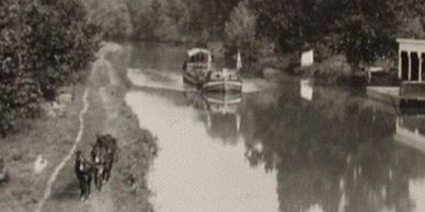
The Chesapeake and Ohio Canal abbreviated as the C&O Canal extends 184.5 miles along the bank of the Potomac River from Washington DC to Cumberland Maryland and played an important role in American history. The canal and the adjacent trail were constructed in 1828 to support the transportation of goods throughout the Potomac valley. The "Grand Old Ditch," as some called it, operated from 1831 until 1924 with a principal cargo of coal from the Allegheny Mountains.
Trees have grown along the towpath preventing the mules from pulling barges plus many sections are dry or contain little water. It has now become a popular recreational trail primarily used by hikers and cyclists.
The towpath is entirely in the state of Maryland and follows the bank of the Potomac River. The river represents the state line separating Maryland from Virginia and West Virginia.
What to expect on the C&O
What to expect on the C&O
What to expect on the C&O
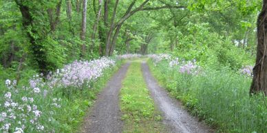
The riding surface of the towpath varies from section to section but most of it can best be described as a dirt road. There are some short paved sections, and a couple dozen miles of manicured crushed stone, but 90% of the towpath looks like the image above. The surface is not terribly rough, but be prepared to navigate around potholes, roots, rocks, and mud. Expect conditions to be a bit rougher than your typical crushed limestone surface found on rail-trails. It's best to select a bike and tires that perform well in muddy conditions and consider yourself lucky if the weather stays dry.
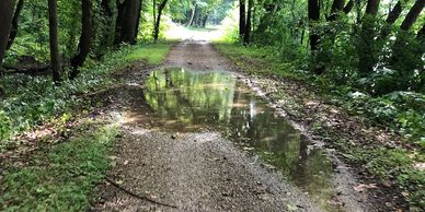
The best trail conditions are found at the ends of the trail and around Harpers Ferry, between Mile 0 thru 20 and Mile 155 thru 184. These sections are heavily traveled so there is more maintenance and are smother with no grass growing down the middle. Other surface improvements can be found between Brunswick and Harpers Ferry and for several miles north of Harpers Ferry. The C&O tends to gather water on the trail forming sometimes unavoidable puddles.
If you ride from DC to Pittsburgh, the Great Allegheny Passage will be welcome relief. The trail is silky smooth compared to the C&O Canal.
Towpath Trail Grade (steepness)
What to expect on the C&O
Towpath Trail Grade (steepness)
The towpath descends 605 feet from Cumberland, Maryland to sea level when it reaches Georgetown, in Washington DC.
This elevation change is spread over 185 miles so the towpath feels basically level, with most of the drops or climbs being in brief 10-foot sections located at the locks.
Because of the relative flatness, the whole path is fairly easy to navigate even for inexperienced cyclists.
Check the National Park Service website for alerts and trail closures. It's common to have sections of the trail closed and sometimes the reroutes will navigate through the hilly terrain which can be considerably more challenging and sometimes dangerous.

Paw Paw Tunnel Detour
The Tunnel Bypass Trail is roughly 1.5 miles in length with an elevation change of 375 feet. The bypass is a fairly steep doubletrack trail on the southern side (.82 mile) and a slightly thinner trail with more roots and rocks on the northern side (.63 mile). Most adult cyclists can navigate the bypass in less than 20
Cool stuff on the C&O Canal
Cycle through history
Cycle through history
Cycle through history

The Chesapeake and Ohio Canal abbreviated as the C&O Canal extends 184.5 miles along the bank of the Potomac River from Washington DC to Cumberland Maryland and played an important role in American history. The canal and the adjacent trail were constructed in 1828 to support the transportation of goods throughout the Potomac valley. The "Grand Old Ditch," as some called it, operated from 1831 until 1924 with a principal cargo of coal from the Allegheny Mountains.
Some of the engineering accomplishments included 74 locks, 11 aqueducts and the infamous Paw Paw tunnel. The tunnel was one of the most challenging projects and today is certainly one of the coolest things to see on the trail. The C&O towpath is great for cycling because the nearly flat trail makes for easy pedaling. Over the 184 miles from Washington to Cumberland the trail only climbs 600 feet in elevation. Come prepared with a camera and a flashlight to capture the highlights along the trail.
Paw Paw Tunnel
Cycle through history
Cycle through history
(mile 156.5) At six-tenths of mile, you can see the arch-shaped light at the opposite end of the tunnel but be careful. The distance is deceiving. It is so dark in the tunnel that without a light you can't see the trail surface. One hundred feet into the tunnel the trail surface fades to black so I illuminated my helmet-mounted light. The surface is hard-packed dirt with random dips and potholes so it's a little tricky without a light.
On a ride from Pittsburgh to DC I stopped at the entrance of the Paw Paw tunnel to take a couple photos. Looking down through the tunnel I could see nothing but the arch-shaped light coming from the southern entrance. About half way through the tunnel, a tour group of about 25 people passed me walking north. Everyone in the group had a light but the tunnel was so dark that I wasn't able to see them approaching until they were within a couple hundred feet away. The trail gets pretty skinny through the tunnel so passing someone requires a slight tilting of the bike to avoid a handlebar collision. Bring a light.
The Nation Park Service website has more details about the tunnel here.
Harpers Ferry
Cycle through history
Harpers Ferry
(mile 61) Harpers Ferry is a tiny village, positioned at the confluence of the Potomac and Shenandoah Rivers. Harpers Ferry National Historical Park surrounds the town, providing visitors with tours, museums, hiking and biking trails --- all within easy walking distance. Today, the majestic beauty of the two rivers and the cliffs surrounding Harpers Ferry draw visitors from all over. The Appalachian Trail goes right through the heart of town. Boutique shops offer a variety of beautiful items for our visitors and local eateries can satisfy the palate. Local outfitters can help with rafting, tubing or kayaking trips.
The Appalachian trail crosses the Potomac at Harpers Ferry via a footbridge which connects the towpath to the town. Riders from the C&O Canal must navigate the same stairwell which climbs up to the footbridge which crosses the Potomac. There stairs were difficult with a loaded bike and BOB trailer. I had to remove the panniers and reattach at the top of the stairs. You can roll off the Harper's Ferry end of the bridge right into town without any stairs or obstacles.
Great Falls
Little Orleans
Harpers Ferry
(mile 14) This is one of the most popular sections on the canal because of the proximity to Washington and the incredible scenic beauty. Vantage points along the trail deliver breathtaking views of Great Falls on the Potomac River. The Historic Great Falls Tavern is home to the Visitor Center with a Bike Rental which is open on weekends. There's plenty of hiking trails to explore along the rivers edge. Click here to download a trail map.
If you're hungry and looking to feast on the areas' most average $16 burger, the Old Anglers Inn restaurant is the perfect place. They have comfortable outdoor seating shaded by mature oaks and accented with a soothing fountain. If your prefer to grab a quick bite, there's a snack
Little Orleans
Little Orleans
Little Orleans
(mile 141) Little Orleans is a popular place to stop because it's 20 miles north to Oldtown and 17 miles south to Hancock. So it's positioned somewhat in the middle of a 40 mile stretch with limited services. Just under the railroad tressel is Bill's place. Bill's Place is a bar, general store and diner. Everyone comes to Bill's Place for its one of a kind atmosphere. This log cabin style building is a favorite stop for a cold drink and an excellent meal.
There's a lodge and a campground not far from Bill's. The Little Orleans campground requires a significant effort to climb the steep hill along Oldtown Orleans Rd. Campground website
Whites Ferry
Little Orleans
Little Orleans
(mile 35.5) There used to be 100 ferries operating on the Potomac, this is the last one and it's still pretty busy. The ferry runs continuously, year round, from 5 a.m. to 11 p.m. There's a fee to use the ferry and it's cash only. More info here.
There's a White's Ferry store and grill that offers decent sandwiches and grill items. This is a good stopping point because
If you need supplies, Leesburg is across the river.
- All autos: One way $5, round trip $8
- Trucks: $5, $7, $9, $12
- Motorcycles: $3
- Bicycles: $2
- Trailers: $3 per axle
- Foot Passengers: $1
For up-to-date conditions, call them at 301-349-5200. Flooding and ice can close the ferry. Once across the ferry to Virginia, the town of Leesburg, is a mile south and has bike shops, restaurants and lodging.
Trail Towns & Lodging

Where to stay overnight
There are people who will ride the entire towpath (184.5 miles) in a single day but most of us will do the ride over multiple days. Part of the planning process is to forecast your daily mileage and then secure lodging in the respective towns. There are basically two lodging options, either pitch a tent or stay in a hotel. Both options have their benefits and the towns along the trail support both styles.
The towns along the trail are typically small with limited lodging options so it's a good idea to make reservations in advance.
No overnight permits required for vehicles in Chesapeake and Ohio Canal parking lots. The National Park Service is not responsible for cars or their contents; do not store valuables in cars.
trail maps
Great Allegheny Passage
Great Allegheny Passage
Great Allegheny Passage

Camping along the C&O Canal
Camping is easy on the C&O
Add adventure to your long distance rides by sleeping under the stars. There's a great feeling of independence when you ride the trail completely self-supported but understand it does require the additional effort of transporting the camping gear.
There are a couple camping options...full service campgrounds and primitive campsites. About half of the trail towns on the GAP have campgrounds and generally offer amenities like showers and laundry. There is a primitive campsite every 5 miles along the towpath and full service campgrounds in some of the larger towns. Primitive camping areas have a hand water pumps at the Hiker/Biker and Drive-In Campsite locations. Water quality tests are performed frequently by park staff to ensure water is drinkable. If the water quality is unsafe the NPS will lock the pump to prevent it's use. Water pumps are available from mid-April to mid-November.
Camping is allowed only in designated sites. If you are planning on leaving a parked car at a C&O Canal Parking lot, visitors must register their vehicle through the new online registration system.
No overnight permits required for vehicles in Chesapeake and Ohio Canal parking lots. The National Park Service is not responsible for cars or their contents; do not store valuables in cars.
A maximum of 2 tents and 8 people per site except for group campsites. Tying ropes to trees and structures is not permitted. The C&O Canal is a Trash Free Park. Please plan to take all trash with you. Group Campsites are located at McCoy's Ferry, Fifteen Mile Creek, Paw Paw Tunnel, and Spring Gap. They are $40 per site, per night with a maximum of 35 people. NO reservations required - first come first
Find a cycle-camping equipment checklist on the REI website. Click here to view the list.
Be safety conscious when you're camping. It's a good habit to lock your bike at night to a nearby tree, pole, picnic table or other such object and then remove all water bottles, lights, and pumps from your bike. Removing them prevents them from getting stolen in the middle of the night. If you leave your light or pump on your bicycle, there is always a chance that someone could help themselves to your gear. When you go to bed each night, make sure that your camp looks impenetrable. The last thing you want on a bicycle tour is to wake up and find that your lights, pump, and water bottles have been stolen. Not a great way to start the day!